Unknown's avatar

Poker Run

The 8th Annual Layne Creed Memorial Ride was held this past Saturday in Mt. Airy, North Carolina.

10488078_745666072143957_773975367115316034_n

10534269_765239673519930_6008200382712688703_n

(photo credits Layne Creed Memorial Ride)

You may remember that I wrote about this ride in 2012.  Check out this link to learn about Layne Creed, his family, and the reason behind the ride.  Over the years, the Memorial Ride has raised well over $55,000 for local EMS, the Surry Community College, and the Children’s Center of Surry, which is where all of this year’s proceeds will go.  In honor and memory of Layne Creed, this memorial ride has become a favorite of North Carolina and Virginia bikers, and has done incredible things for the community that Layne called home.

Each year a group of friends rides down from Virginia, and this year we were geared up for rain.

IMG_8182

As always, the Poker Run starts at 13 Bones in Mt Airy, NC, a local restaurant known as much for their charitable donations as they are their good food. A  poker run is an organized event where motorcycles (or boats, cars, bicycles) and their riders visit five checkpoints, drawing a card at each one. The one with the best poker hand at the end is the winner … although really, it is the children that are the winners.

IMG_8207-2

IMG_8188-2

A new checkpoint in the ride this year was Round Peak Vineyards.

_MG_8221-2 _MG_8220-2 _MG_8218-2 _MG_8217-2

As is obvious from the photos, the clouds threatened rain all day long.

_MG_8229-2

_MG_8227-2

Luck was with us though and we rode on dry roads.

The donations are still coming in, but the last I heard, around $7000 was raised.  An incredible amount of time and energy is put into the ride each year, but the Creed family gladly does it to benefit the children of Surry and Yadkin Counties …

10616587_774871749223389_9060659445763159484_n

(photo credit Velvet Creed Leonard)

… and in honor of their loved one, Layne Creed.

IMG_8238-2

You can visit the Layne Creed Memorial Ride on Facebook and see lots of photos of bikes, riders, and fun!

Unknown's avatar

Ride to Paint Bank

The meet time for the ride: 10:45.  The destination: Paint Bank, a small community in northern Craig County, Virginia.

_MG_8115-2

The train depot dates back to 1909, when Paint Bank was the final stop of the Potts Valley Branch line of the Norfolk & Western Railway, which was expanded during the mining boom of the early 1900’s.

_MG_8116-2

The lodge features a master suite, and 4 guest rooms each with private bath, and a gas fireplace.

_MG_8118-2

The caboose has been renovated into a queen bedroom, complete with it’s own bath.

_MG_8119-2

The Depot and the other buildings in Paint Bank have been beautifully renovated and visitors can shop in the General Store, eat in the Swinging Bridge Restaurant (which really does have a swinging bridge inside it), and explore the water powered Grist Mill.

_MG_8120-2

I’ve ridden to Paint Bank several times through the years and it’s a great place for a stop along the way.  Someday I’ll have to stay the night!

_MG_8121-2_MG_8123-2 _MG_8125-2

It was a misty ride back over the mountains towards home, but despite the dark storm clouds only a few of the 160 miles we rode were truly rainy.  Another fun ride in the books.

And oh yes!

The best sign I saw along the road today was in front of a church: “Noah should have slapped those 2 mosquitos”

🙂

Unknown's avatar

Thunder Ridge

The Blue Ridge Parkway (BRP) is a 469 mile drive that connects the Great Smoky Mountains National Park in North Carolina and the Shenandoah National Park in Virginia, and I’ve ridden every one of those miles on the bike.  In fact, I took my first solo ride on the BRP, celebrating my 50th Birthday, 4 years, and 2 cameras, ago. You can read about that ride here and here if you’d like.

Even though I’ve ridden on the BRP many times, I still see something new with each visit.

IMG_7987-2

 Yesterday’s 230 mile ride, part of which was on the BRP, included a stop at Thunder Ridge, at Milepost 75.

IMG_7984-2

IMG_7986-2

A very short hike reveals a view of the Allegheny Mountains and Arnold’s Valley, elevation 3485 ft.

IMG_7989-2

The view made me think of a blanket made of mountains.

IMG_7990-2

We stood there admiring this incredible view, feeling the sun on our faces while the wind blew with gusto, and then took the trail back to the bikes.

IMG_7993-2

What an incredible gift it is to live right near the Blue Ridge Parkway.

“Celebrating its 75th anniversary in 2010, the Blue Ridge Parkway is a product of the New Deal’s efforts to provide jobs to the unemployed of the Great Depression. Construction began in September 1935 at Cumberland Knob near the North Carolina and Virginia state line.

The idea was to create a link between the Shenandoah National Park to the edge of the Great Smoky Mountain National Park. Completed in 1983, the Parkway’s history has been highlighted by documentarian Ken Burns in the six-part “The National Parks: America’s Best Idea” series originally aired on PBS”.

Unknown's avatar

Kentucky and the “Niagara Falls of the South”

As I wiped the mud and water from my bike, I thought about how grateful I was for the warm welcome that I’d received when I checked into the hotel the night before.  Hotels typically treat bikers well, and this time was no exception.  I was allowed to park the bike under the covered entrance, was given rags to clean the bike, given recommendations for local eateries, and received a gift of water and trail mix.  Betty surely made me feel welcome and a note was sent to her manager to praise her efforts.

The continued calls for rain had me considering heading home a day early, but as I cleaned up the bike I made the decision to take my chances.  Kentucky still had alot to show me after all!

After packing up the bike and filling the tank, I set out for Cumberland Falls State Park.  25 E was a beautiful ride, and I passed by wooded lands and farms situated on nicely curving roads.  Once inside the Daniel Boone National Forest, where the park is located, I had to keep myself from pulling over every few miles to take photos.  The woods were lush and green and I was captivated.

One of the first things I saw upon entering the park was the Dupont Lodge.

_MG_7514

The Civilian Conservation Corps, under Roosevelt’s New Deal, put jobless men and boys throughout the United States to work.  Built by the CCC in 1933, the historic lodge was destroyed by fire in 1940. It was re-built soon after the fire, and all rooms were completely renovated again in 2006.

_MG_7509

The staff offered much information including directions to a half mile trail, with a 200 ft descent, that led to the falls.  Since my boots were still a bit wet, I was glad I’d only be hiking a short way, but I was definitely ready to get off the bike and into the woods.  I grabbed my water bottle and headed off on foot.

_MG_7515

IMG_7522 _MG_7516

I have to admit to being a bit skeptical about the whole “Niagara of the South” label, but oh, I was pleasantly surprised!

IMG_20140809_124108

Since the early 1900s, Cumberland Falls has been known as the “Niagara of the South”.  “Falling 7 stories, it is one of the largest waterfalls in the southeastern U.S.”.

_MG_7534

_MG_7539 _MG_7531 _MG_7537

Even though I was just one of many people there to enjoy the falls, I never felt that it was crowded.

_MG_7557 _MG_7545 _MG_7551

I spent over an hour wandering about, taking pictures from a variety of angles and places, and learning about the history of the river and the falls.

_MG_7558

The hike back up aggravated the new blister on my heel (thanks to the darn damp boots).  But what fun it was to sit outside the lodge, applying first aide to my heel and talking with all the folks who stopped by to admire my bike.  I’d been missing the human connection this trip as the rain kept me from alot of stopping and chatting.

IMG_7562

While I’d been lucky this day, I knew that as I turned for home the weather would change, and I’d eventually run into rain again, so I made the decision to head on back towards Virginia.  I rode through more beautiful country on curvy roads and found myself singing out loud with the joy of the wind in my face and even the occasional glimpse of sun.

As the day waned, I turned onto Rt 58 and my happiness continued.

_MG_7577 _MG_7575

My friend Tim helped me to find a hotel in Johnson City, Tennessee and one of the first things I did was ask the hotel clerk where I might find a cold beer 🙂

IMG_20140809_211923

Once back at the hotel, the clerk told me to be sure to park right in front.  It’s good to be a biker!

_MG_7576

Next Post:  The Ride Home

Unknown's avatar

Kentucky: Wet Roads Through Dry Counties to The Cumberland Gap

80% chance of rain!

That’s what I would be riding in, and since there was one more trail that I wanted to walk, I was up and out of my room early. The trail led me to The Towers overlook but since it was a misty morning, the views were limited.  Even still, my walk into the woods was intriguing, even mysterious, as I had no idea what was around the curve in the trail.

_MG_7481

_MG_7482

_MG_7489

Once back from my walk, I hit the dining room for breakfast and just as I finished and walked outside, the rain began, although lightly.  The housekeeping staff gave me some extra plastic bags (to pack wet things in later) and I left the Breaks.

With each mile, the rain came harder, but it wasn’t so hard that I felt the need to pull over.  I rode on some twisty, turning, beautiful roads.  Oh how I wished I was riding them on a sunny day!  The rain seemed to emphasize the poverty in some of the very small, remote communities that I rode through.  Signs of support (and opposition) to the coal industry were everywhere.

As I rode, I kept wishing I could stop to take photos, but the rain kept coming down. I rode between rocky, tree covered hills on my right, and river beds and ravines on my left.  Simply gorgeous!  The weather forced me to rearrange my route slightly, and at one point, I turned around and out of Kingdom Come State Park when I hit an unpaved, incredibly hilly road called the Little Shepherd Trail.

My goal, since I was riding alone, was to stay safe,  be smart, and have a different outcome from my ride last fall.  In other words, arrive home safely.  Even still, I was disappointed that I would not be able to explore the park, named after a Civil War novel, “The Little Shepherd of Kingdom Come,” by Kentucky author John Fox Jr.  Kingdom Come State Park preserves 1,283 acres of unspoiled wilderness.

At one point I was forced to stop for road work.  A 25 minute stop.  On a steep hill.  Holding onto the brake.  Unable to go forward, backward, or to get off the bike, I watched crews work to straighten out an incredibly curvy road through a tiny little hill town.  Phew!  My guess it will take years to finish that road.

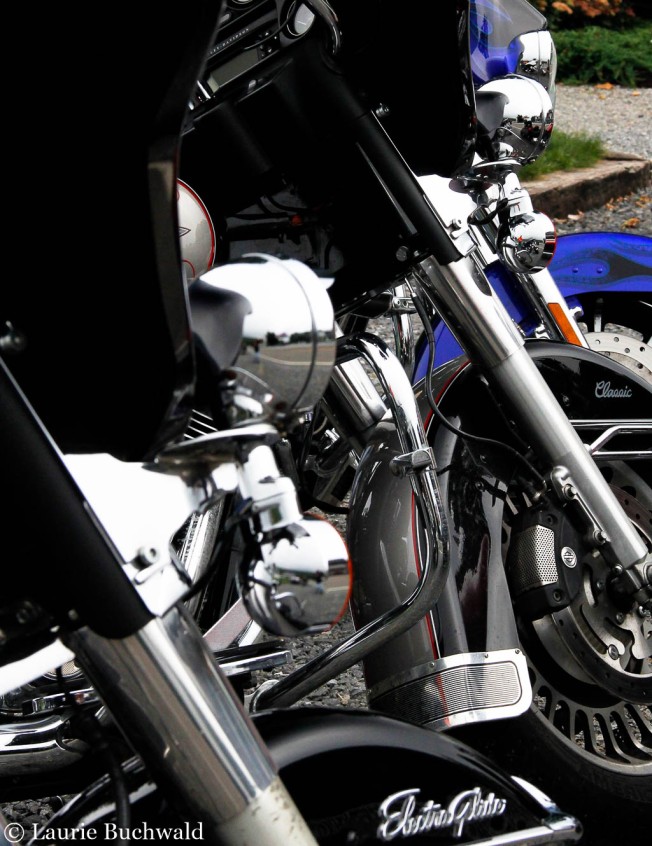
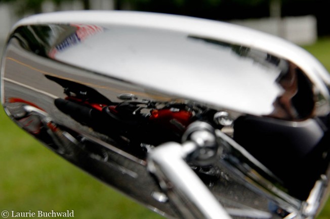
After about 4 hours, the rain slowed and finally stopped, and I stopped for gas.  Since I’m not able to share photos from the ride, I thought you might want to see the result of the ride on my pretty bike.

_MG_7492

My plan was to stay at Pine Mountain State Park, but when I got there, the lodge was booked.  It was time to ride on, explore the surrounding area, and think about where to stay for the night.

As an aside, by now I’d also learned that not only were the State Parks in Kentucky alcohol free, but the entire part of the state in which I was traveling was DRY.  According to Wikipedia, “the alcohol laws of Kentucky lead to a confusing patchwork of counties that are dry (prohibiting all sale of alcoholic beverages), wet (permitting full retail sales), and moist (occupying a middle group between the two)”.

Of the 120 counties in Kentucky, 55 are dry … and those are the ones I was riding through.

When I walked into the Visitors Center at Cumberland Gap National HistoricalPark, I was greeted by a wonderful Brit who not only gave me information about the park, but also a list of nearby hotels, and directions to Pappy’s Beer & Wine.  In order to get to Pappy’s, I had to ride through the very cool Cumberland Gap Tunnel, out of the state of Kentucky, into the state of Tennessee, and then back into Kentucky with a bottle of red wine safely tucked into my saddle bag.

Cumb_Gap_Tunnel_S

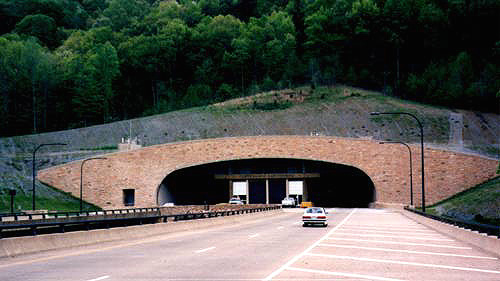
(photo credit: http://www.roadstothefuture.com/Cumberland_Gap)

IMG_20140808_164214

After securing a hotel room for the night, I rode to the top of the Cumberland Gap, “the first great gateway to the west”, where the buffalo, the Native American, the longhunter, the pioneer all traveled this route through the mountains into the wilderness of Kentucky.  For many, it was the way to a new life in the frontier wilderness. Through the Cumberland Gap, a natural passage through the forbidding Allegheny Mountains, passed the Wilderness Road.  Hacked out in 1775 into by a party led by Daniel Boone, this road was one of the main arteries used by the settlers who occupied the region between the Appalachians and the Mississippi River (http://www.legendsofamerica.com/ky-cumberlandgap.html).

This cabin, a replica of an original pioneer cabin, stands near the Visitors Center.

_MG_7572

_MG_7573

The ride to the top was one 180 degree turn after another, with each turn an elevation change.  Thank goodness there was little traffic as I was challenged by that ride.  While my photos from the top of the Gap reveal the continued overcast, foggy day, I thought you’d appreciate seeing one that I downloaded.  The first are mine, the last is not.

IMG_7497

As I stood there, looking at that beautiful scene, the mists and clouds rolled right over me.

IMG_7500

IMG_7498

IMG_7503

This is what I hope to see when I return on a beautiful day.

cumberland_gap

I spent two hours in this national historical park, but could have spent more.  So much history, so much to learn! As evening approached, I checked into my hotel and found a wonderful locally owned restaurant in downtown, historic Middlesboro.  A delicious meal at Shades Coffeeshop was followed by a lovely plastic cup of wine in my hotel room surrounded by drying bike gear.  Ah, life is good!

And tomorrow, my Kentucky adventure continues!

Unknown's avatar

Breaks Interstate Park – Virginia and Kentucky

Despite the fact that every weather report called for extensive rain, I was ready to ride!  My goal for this ride, my first trip on the bike since the wreck 10 months ago, was to take my time, enjoy the adventure, and have a completely different outcome from the last one.  To say the least, I was excited!

The destination for this, the first day, was Breaks Interstate Park, a park shared by the states of Virginia and Kentucky.

_MG_7428

I took a chance and kept my rain gear packed in the saddle bags and hit the road.  The day was overcast and just a little cool … in essence, a perfect day to ride.   As I got closer to the park the roads became curvier and the traffic became more sparse.  About four hours later and just a few miles before entering the park, I stopped at Mill Rock Point Overlook.  A short 65 yard hike, and I was taking my first photos of the trip!

_MG_7421

 _MG_7426 _MG_7424

Shortly after that, I entered what is known as the “Grand Canyon of the South”.  200 million years ago the area was covered by a vast inland sea.  Once the sea receded, the river that is now known as Russell Fork began the work of carving out an immense gorge, renowned as the largest east of the Mississippi.

I rode straight to the Visitors Center, and was immediately distracted by this historic log cabin.

IMG_7434

It was while chatting with the woman at the Visitors Center, and hoping to quench my thirst, that I realized my first error in planning.  There would be no traditional end of the day beer as there areNO ALCOHOL sales in the park!  Ah well, at least I was able to enjoy a cold ice cream cone!

The park has several trails and I set off to hike a few of them.  Most were less than a mile and all of them led to various views of the 5 mile gorge.

_MG_7442

_MG_7439

These images look similar but the clouds kept changing and I could not stop shooting!

_MG_7446

It was 6 oclock in the evening and I met no one else on the trails and saw no one at the overlooks.  Perfect!

_MG_7447_MG_7459

From this vantage point, I was standing in Virginia and looking at both Kentucky and Virginia.

_MG_7462 _MG_7443

All I could hear was the sound of the river, the train, and hawks flying around overhead.

_MG_7465

I had to chuckle as I came upon this sign and of course, ventured beyond.

IMG_7452 IMG_7453 IMG_7450

After several hours of riding and a few hours of hiking, it was time to head to the lodge for supper.  While I had to settle for unsweet iced tea, I thoroughly enjoyed the restaurant’s specialty of brown beans and cornbread.  Time on the deck was the only dessert that I needed.

IMG_7467 _MG_7471

With the bike parked right outside my room, I settled in for the night.  I managed to escape the rain this day, but I knew that there was a good chance I’d be riding in the rain soon.

IMG_7475

Next Post: Onward into Kentucky

Unknown's avatar

Home!

Hello from the very rainy Commonwealth of Virginia!

_MG_7595

I’m back from vacation, during which I saw very little sun, but had a wonderful time!  Luckily, I only rode in about 6 hours of rain, 2 of which were the final hours before arriving home.  If you were to visit me right now, you would see drying bike gear everywhere!

I’m anxious to catch up with your blogs and plan to visit within the next 24 hours!  And of course, soon I’ll be sharing photos and notes from my travels.  I’ll hope that some of our rain pushes west in order to provide relief to the draught stricken!

Unknown's avatar

300 Miles for A Cold One

The text came in on Saturday night. “Meeting at 9am for a ride to Devils Backbone Brewery.  It’ll be an all dayer”

_MG_6309

It was indeed an all dayer, with enough stops along the way to see the big perspective …

_MG_6314 _MG_6319

… and the small.

_MG_6316 _MG_6323

While the ride is the reason, this day’s destination was pretty great.

_MG_6332

Devils Backbone Brewery, established in 2008, is an award winning craft brewpub in Virginia.  There’s nothing like pulling up, all hot and dusty, knowing that inside awaits a cold beer and a delicious plate of Fish and Chips.

_MG_6329

Quite simply, a wonderful day … on and off the bike!

_MG_6328

If you’re in the area, be sure to stop in.  Joe, that means you, too! It’s well worth the visit.

Unknown's avatar

Join Me on a Little Local Ride

One of the challenges for any weekend is to somehow get all the chores on the “to do” list done, yet still find time to play.  By 3pm this past Sunday, I’d accomplished enough to be able to head out for a little local ride.  Luckily for me, local riding often means country roads, fields, lakes, and historic communities.

Dry Valley

_MG_5646

Claytor Lake is a reservoir of The New River, created when a hydroelectric dam was built in 1939.  I stopped for a water break and the chance to watch the geese and ducks.  It was a perfect afternoon to ride, but the bright sun made for challenging photography.

_MG_5667_MG_5647 _MG_5662

Yes! That is a lighthouse! On the lake 🙂

_MG_5665_MG_5670

Soon it was time to ride on down to the end of the road.

_MG_5671_MG_5673

I’ve photographed this slowly decaying barn from many angles … it’s a beauty.

091_MG_5679

From there, I rode through the community of Newbern, listed on the National Register of Historic Places.  I’ve ridden through the Newbern Historic District many, many times but somehow had missed these two structures.

The Old County Jail and site of the First Courthouse of Pulaski County

_MG_5692 _MG_5681 _MG_5682_MG_5686 _MG_5690 _MG_5691

The original reservoir for the Newbern Waterworks

_MG_5699_MG_5694 _MG_5697 _MG_5698

A little beauty, a little history, a little photography … all seen from the bike. Not a bad way to spend a few hours.

Unknown's avatar

A Golden Stop

At the end of a day of travel, I was prompted to pull the truck over to capture this golden scene.

_MG_5205

_MG_5201

Just think! Soon I’ll be pulling over on the bike because Yes!  The new bike is in the driveway!

_MG_5214